​​​​​​​​​​​​​​​​​​​​​​​​​​​​​​​​​​​​​​

Public Meeting

Bonefish Cove Habitat Restoration Project

​Thursday, February 29, 2024 at 5:30pm
​​Town of Lantana Town Hall​
500 Greynolds Circle, Lantana FL 33462

Join representatives from Palm Beach County and the US Army Corps of Engineers (ACOE) to learn more about Bonefish Cove Habitat Restoration Project​, ask questions, and provide feedback at this informative workshop.

Lake Worth Lagoon Logo 


Aerial Photograph of Lake Worth Lagoon Estuary Taken at South Lake Worth (Boynton) Inlet 

Palm Beach County's Lar​​gest Estuary 

Spanning 20 miles from North Palm Beach to Ocean Ridge, Lake Worth Lagoon is where ocean water flows in through 2 inlets and mixes with freshwater flowing through 3 major flood control canals that drain over 350,000 acres of land.  This mixture of fresh and salt water turns brackish and is critical habitat to a wide variety of plants and animals.  In addition, the Atlantic Intracoastal Waterway cuts through the estuary as it traverses the east coast and is a source of food, recreation, transportation, employment, and coastal protection for populations living along it.

 
Picture of American Oystercatcher Shorebirds, 2 Chicks and 1 Adult Parent at Lake Worth Lagoon Estuary 

What Makes Estuaries Special?

The environment in an estuary is dynamic.  It changes daily - tides move in and out of the inlets - AND seasonally - rainy season drives more freshwater through the canals. Life in Lake Worth Lagoon must adapt to changes in water temperature, salinity, turbidity, depth and flow. 

And while change is what defines an estuary, the result is what makes it highly productive.  Estuaries are the nurseries of the sea by serving as a refuge for species to complete their life-cycle.  Lake Worth Lagoon estuary is a birthing area, safe haven for juveniles to mature, transportation corridor with rest areas during migration, nesting area, and source of food. 


Picture of Lake Worth Lagoon Estuary Circa 1920

History of Lake Worth Lagoon Estuary


Lake Worth Lagoon estuary started out as a freshwater lake sealed off from the ocean by barrier islands. Water would flow into the lake from the western interior wetland forests, prairies, and marshes.  The lake was an important source of freshwater along the east coast provided wildlife and indigenous people with drinking water, food, and transportation. The Seminoles called it “Hypoluxo” meaning “water all around, no get out.”          


1800s


As settlers began to move into the area in the mid 1800s, the freshwater lake was changed into a brackish estuary when pioneers dug the first stable inlet just north of Lake Worth Inlet. The estuary was further altered when the Atlantic Intracoastal Waterway dredging was completed in the early 1900s.


1900s


In the early 1900s, the current Lake Worth Inlet was dug out and underwent modification over the years making it deeper and wider to improve shipping, transportation, and water quality.  In the mid 1900s, a system of canals were dug to drain lands to the west for development resulting in a large amount of freshwater being discharged into the lagoon. Pollutants from untreated freshwater discharges and sewage was released into the lagoon causing poor water quality. To provide some relief, the South Lake Worth Inlet was dredged to provide additional flushing of clean ocean water into the lagoon.  Development continued along the lagoon replacing most of the mangroves and natural shoreline with seawalls and bulkheads. Continued discharges caused a tipping point in the late 1990s and people started to take notice that something was wrong.             

Map of Lake Worth Lagoon Estuary 

Picture Showing Human Impacts to Lake Worth Lagoon Estuary
 

A Lake Worth Saving

Restoring Tidal Flat Areas

Johns Island

johns island picture  


Originally this low lying tidal area was impacted by soil being placed on it from dredging the Intracoastal Waterway for many years.  ERM restored the island by removing the soil which created optimal conditions for salt marsh, mangrove, seagrass, oysters and tropical maritime habitats.  One of the highlights of this island is a 14 acre oyster bar that filters the water column as freshwater flows into the estuary from inland through the C-51 Canal.  The island is managed by Audubon.

Creating Living Shorelines


living shore line currie picture 


Where seawalls line the lagoon, ERM's restoration efforts focus on installing elevated planters that flood at high tide.  Mud flats, nooks and crannies in the limestone rock, and the salt marsh grasses all provide habitat for fiddler crabs, birds, and oysters. These projects can be found along publically owned lands within the  City of West Palm Beach at Currie Park (featured) and Osprey Park; City of Lake Worth at Bryant Park, Jewell Cove, and Old Bridge Park; and Town of Lantana at Bicentennial Park, Lyman Park, and Lantana Nature Preserve.

​Exploring the Lagoon


There is much to see and do in the lagoon when you visit one of these ERM restoration areas that have public use amenities offering a range of activities for everyone. 


Munyon Island

munyon island picture


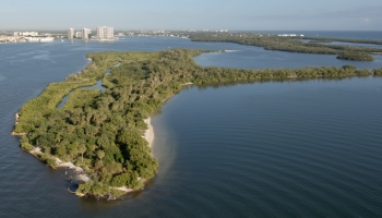
Once considered the largest wading bird rookery in South Florida in the 1800s, this island became a destination in the 1900s for wealthy Northerners to recuperate from their ailments at Dr. Munyon's Hotel Hygeia where they would drink his "Paw-Paw Elixir" to heal their aches and pains. In the 1930s and 1960s, the island was impacted when large amounts of soil were placed on it as the Intracoastal Waterway channel was dug out.  In the 1990s, ERM removed the soil, created tidal channels and ponds to increase water flushing, and restored 20 acres of mangrove trees and salt marsh grasses, 23 acres of maritime hammock forest, and 9 acres of underwater seagrass beds.


The island is part of the John D. MacArthur Beach State Park managed by the Florida Park Service.  The best way to visit this historical island once called "Nuctsachoo" or Pelican Island by the Seminole Indians is by kayak which you can rent at the gift shop.


Click here to learn more.


Peanut Island


peanut island picture 


Since the early 1900s, this site has been the location to store soil removed to create the Lake Worth Inlet and to maintain the Intracoastal Waterway.  As the island grew, exotic trees such as Australian pines infested the property resulting in poor habitat. In 2005, ERM removed soil to create reefs, beaches, dunes, and maritime hammock and mangrove forests on this 79-acre island that gets bathed in the crystal clear Atlantic Ocean waters.


Palm Beach County's Parks and Recreation manages the site which hosts activities such as swimming, snorkeling, and camping.


Click here to learn more.


Snook Islands Natural Area


Snook Islands picture 


ERM repurposed 1.2 million cubic yards of sand from Peanut Island and moved it south to fill a large degraded area in the lagoon by the Lake Worth Bridge that had become void of oxygen from years of dredging.  Over 11 acres of mangroves, 2 acres of oysters, 3 acres of salt marsh grass, and 60 acres of seagrass habitat were created north and south of the bridge.


Click here for more information.

South Cove Natural Area


south cove picture 

For years dredging activities just north of the Royal Park Bridge along the Downtown West Palm Beach Waterfront left a 7 acre hole in the lagoon floor that filled in with muck sediment providing little habitat value and an anoxic (lacking oxygen)  environment.  ERM used clean sand to cap (cover and contain) the muck, formed 3 intertidal mangrove and salt marsh islands totaling 2 acres, created 3.5 acres of seagrass habitat and 1 acre of oyster reef habitat. 


Click here for more information.

Ocean Ridge Natural Area

Ocean Ridge natural area picture  

ERM restored this 9.5 acre island south of the Ocean Avenue Bridge in 2006.  The maritime hammock habitat had become degraded over the years due to surrounding development that caused a loss of mangroves and increased exotic invasive vegetation growth.  The natural area is accessible by foot or water traffic (motorized watercraft under 30 feet or kayak/canoe/paddleboard)  making it a very quiet place to visit and observe wildlife.


Click here for more information.
 

Life in the Lagoon


The scenic waters may provide an economic and recreational value to our area, but it's the life within the estuary that makes it so special.  You are likely to see many of these critters in the lagoon.

Fish

snook picture

Over 250 species of fish like common snook (pictured), puffer fish, and bonefish use the lagoon.  Some live out their entire lives in the waterway, others use the protection it offers for breeding, nursery grounds to mature, and to recharge from life the Atlantic Ocean.

Sea Turtles

 green sea turtle picture

It's not just our beaches that sea turtles visit.  Juvenile green sea turtles love the northern section of the lagoon and are found in large numbers there making the waterway a crucial component in their development and continued survival.

Oysters

​ ​​
Close up image of oysters

These filter feeders remove algae, other microorganisms, pollutants and particulates from water flowing through their gills and can improve water quality.​​​

Mangroves

lagoon mangroves picture 

These tropical salt tolerant trees use to line the waterway providing safe refuge for wildlife - birds, juvenile fish, crustaceans.

Birds

Picture of an American Oystercatcher Shorebird Adult and Baby

Over 100 species of birds including raptors, migratory songbirds, wading birds and shorebirds use the lagoon for food and refuge. The American Oystercatcher (pictured) is a species of special concern that has bred at restored areas within the lagoon for more than 10 years.

Manatees

Lagoon Manatee picture 

These large mammals swim in the lagoon all year long searching for food, mates, and rest areas.  But when the temperature drops, their numbers spike as travelers migrating up the coast find respite in the warmer waters of the lagoon.

Reefs

 lagoon reefs picture

Rocks and three dimensional oyster structures provide nooks and crannies for small marine invertebrates and juvenile fish to hide, as well as adult fish to spawn.

Seagrass

sea grass picture 

Food for green sea turtles and manatees, these underwater flowering plants break down into  matter that forms the base of the food chain.