Welcome to the working page for the creation of a Pioneer Road Rural Enclave Overlay for the land area within the boundaries of the Pioneer Road Neighborhood Plan. This page was created in August of 2020. Please visit this page frequently for the latest information.
Pioneer Road Neighborhood Rural Enclave Overlay
On October 31, 2018, the Board of County Commissioners initiated an amendment to the Comprehensive Plan to establish the Pioneer Road Neighborhood Rural Enclave Overlay. The draft Overlay language will be prepared by Planning staff and coordinated with neighborhood residents through communication on this website. The scope of the overlay has not yet been determined and will be discussed with the residents through the coordination process. Once the initial draft of the overlay is prepared and reviewed with the neighborhood, staff will coordinate with other County departments for review and ultimately present the language and staff report to the Planning Commission and Board of County Commissioners and public hearings.
Rural Enclave Overlay
Comprehensive Plan Future Land Use Element
Policy2.2.1-w provides for the creation of Rural Enclave Overlays within the Urban Service Area of the County. This policy was adopted by
Ordinance 2018-031. The policy states:
Policy 2.2.1-w: The County shall adopt specific overlays in the Comprehensive Plan and/or Unified Land Development Code to protect the character of individual rural enclaves identified through the neighborhood planning process.
If the Pioneer Road Rural Enclave Overlay is adopted by the Board of County Commissioners, the Overlay will consist of language in the Future Land Use Element of the Comprehensive Plan and the boundaries will be depicted on the Special Planning Area Map in the Comprehensive Plan Map Series. Links to these documents with examples of other Overlays in the County are provided below:
Future Land Use Element
Special Planning Areas Map
Pioneer Road Neighborhood Plan
The Pioneer Road Neighborhood Plan was created through a grass roots effort of local property and home owners. The Pioneer Road Neighborhood is comprised of large lot homesteads and agricultural uses on acres of land, generally located west of Jog Road, south of Southern Boulevard, east of Florida's Turnpike, and north of Okeeheelee Park. The Neighborhood Plan was formally received and filed by the Board of County Commissioners on July 24, 2013 and added to the list of neighborhood plans recognized by the County through a text amendment to the Comprehensive Plan in April 2014. The Neighborhood Plan boundaries are depicted below.
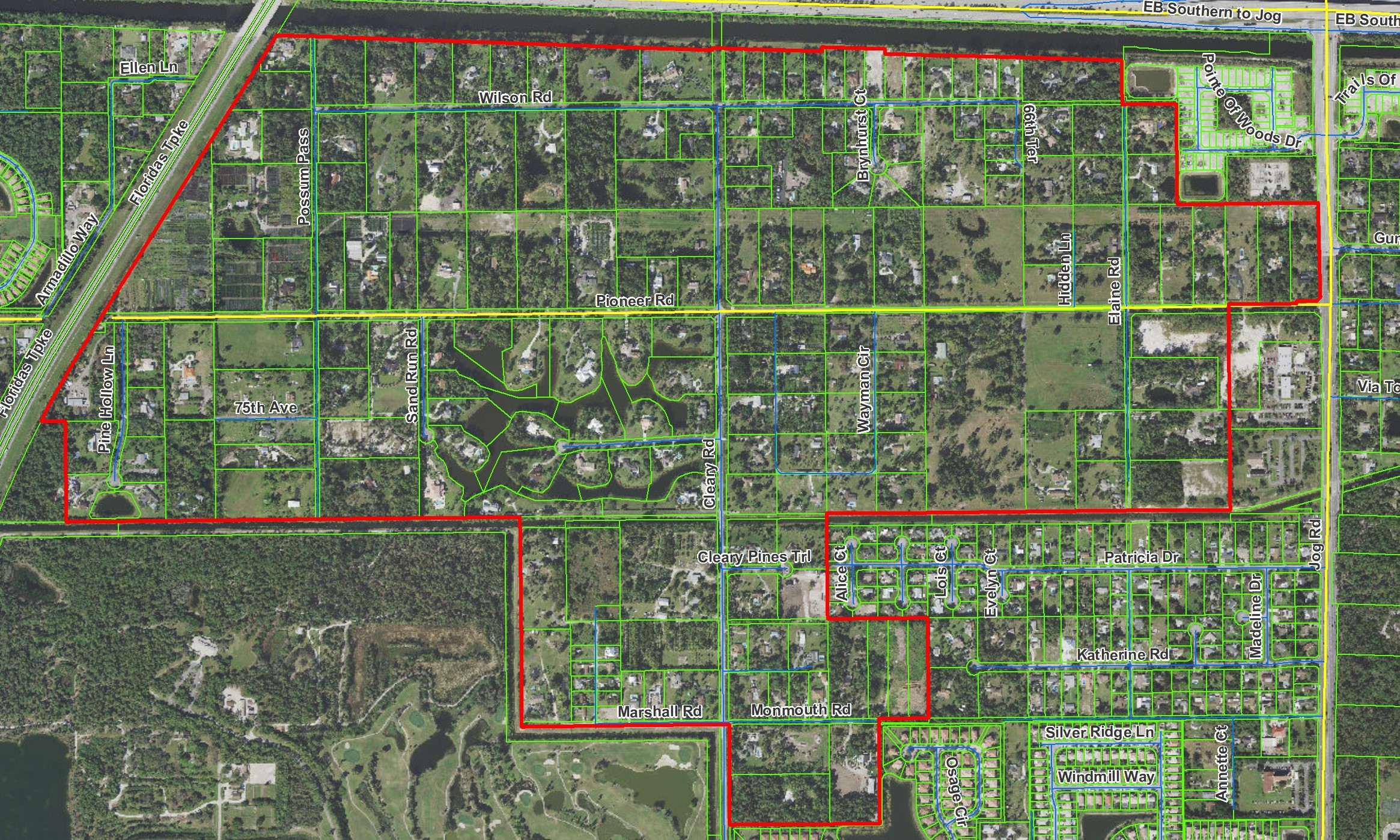
Pioneer Road Maps and Data
The Pioneer Road Neighborhood Plan boundaries consists of approximately 559 acres of land, with an average lot size of 2.8 acres and a predominate future land use designation of Low Residential, 1 unit per acre (LR-1). Key maps are provided below.
 Future Land Use Designations
Zoning Districts
Lot Sizes
Meeting Dates, Agendas, and Summaries
As the preparation of the overlay continues, meeting dates, agendas with back-up, and summaries will be posted below.
| Meeting Date / Notice |
Agenda |
Summary / Minutes |
Tuesday, Nov 17, 2020 Meeting via WebEx | 11/17/20 Agenda Presentation | Video |
Thursday, August 12, 2021 at 4pm | 8/12/21 Agenda Presentation | Video |
Thursday, September 9, 2021 at 4pm | 9/9/21 Agenda Presentation | Video |
Planning Commission Friday, October 1, 2021 at 9am | Agenda | Video |
Board of County Commissioners Transmittal Public Hearing Wednesday, November 3, 2021 at 9:30am | Agenda | Video |